Lend Us Your Sand

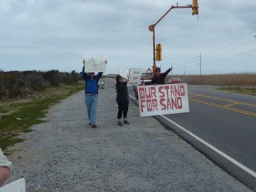
A rally was held March 28, within sight of the dredge barge in Oregon Inlet, to draw attention to beach erosion on Hatteras Island. Several dozen people hoisted poster board signs saying "Save Our Sand," and encouraged passing motorists to honk in support.
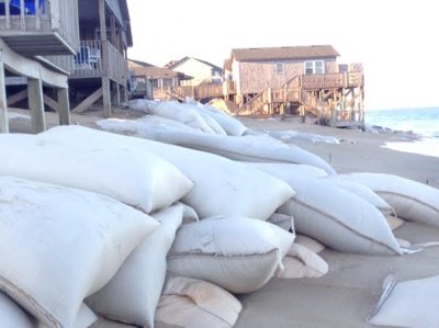
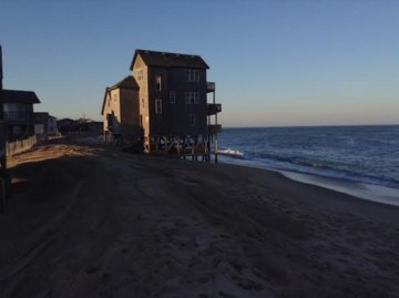
The dredging of Oregon Inlet contributes to erosion on beaches south of that waterway, said Carol Dillon Dawson, owner of the Cape Hatteras Hotel at the northern edge of Buxton village. She has a front row seat, observing the beaches adjacent to her property grow narrower with each passing season. Small dunes of sand are taking shape around the parking lots of her family's hotel, a long standing business on both sides of Highway 12.
"I'm involved because I'm a native," said Dawson, a lifelong resident whose "ancestors were shipwrecked on these islands." Her 85 year old mother, Carol Dillon, attended the rally, and has childhood memories of a quarter mile wide beach behind the Hatteras lighthouse.
The narrowing beach threatens homes, businesses and Buxton's historic village, said Christie Roberson, who owns a home in Buxton. "It's almost simplistic what we're looking for," said Roberson. The group wants the Army Corps of Engineers to direct dredges to put the sand from Oregon Inlet onto the beach, rather than into the sound or offshore.

Pumping the dredge spoils from Oregon Inlet toward the beach side, rather than the sound side, could help ameliorate the problem, said Dawson, who spent the winter researching the problem and contacting coastal geologists. Current dredging protocol either pumps sand onto spoils islands west of the bridge, or carries sand offshore to dump it.
Government agencies stopped taking measures to prevent beach erosion when they moved the Hatteras lighthouse in 1999, said Roberson. She also has a home in Atlantic Beach, where as a member of the town council she worked with local representatives and the Army Corps of Engineers to establish a beach re-nourishment program. Government on a local level is "lacking here," said Roberson, who has been in contact with Congressman Walter Jones' office.
Buxton puts the "cape" in Cape Hatteras. The village grew in the nook of barrier island shaped by the offshore collision of major Atlantic players: the Gulf Stream and the Labrador Current. On Hatteras, it is the "original vacation public beach," said Dawson.
"Property owners have put millions of dollars to maintain cottages and businesses. All of us provide beach access free to the public. We are the caretakers of the beach area, and the heart of Hatteras Island's commercial district," said Dawson.

She is concerned that with the current trends, "We won't make it through next hurricane season," and that "Buxton is going to be the next inlet if they don't do something." She hopes the rally will bring attention to the issue.
"Cape Hatteras seashore is gone," wrote Roberson in an email that offered a number of photos documenting the thin line between private property and the ocean.
The government "told us in 1971 that they're letting nature take its course," said Dawson, who noted that they also "built a bridge in one particular spot on a barrier island." The hospitality jobs on Hatteras are just as important as the commercial and charter fishing jobs that depend on a navigable inlet, said Dawson.
Geologist Orrin Pilkey of Duke University – the mention of his name caused Dawson to shudder – has been influential in arguing for letting nature take its course on barrier islands, which naturally shift. Modern islanders are dealing with many concerns, among them what it means to own property that may disappear underwater.

A few years ago I heard a tale from a coastal engineer who worked on Hatteras Island in the 1980s. He and a team were surveying a site for commercial development. The survey markers didn't match their expectations. It was perplexing. They knocked on the door of a nearby home, seeking clarification, and were greeted by a weathered old islander. The markers were right where they should be, he assured them. A hurricane four or five decades earlier had carried his home to a new site, and he, reasonably enough, moved the survey marks to reflect the scope of his property.
Some aspects of local heritage are difficult to emulate in 2014.
Barrier islands bear the brunt of storms, and protect all of NC. Residents all along the Outer Banks should share the same concerns. "We are one," said Dawson.
Donna from Kill Devil Hills, a town that is no stranger to beach erosion, drove down to show her support. "Put the sand back on the beach where it came from, so it can wash back in again," she said.


