The Waiting Game
DISCLAIMER: Capt. Rob is not and does not claim to be a meteorologist. Relying on his weather opinions would be like turning to Gary Johnson for a geography lesson or to Donald Trump for an accurate statement on anything.
As if I don’t have enough to do with a potential hurricane approaching, once again I come under spousal pressure to “write something about the hurricane for the Current.”
She insists there are some readers under the impression that I, as a grey-bearded sailor, might have some useful insights that the National Weather Service with its space-age technology and scores of highly-trained meteorologists might have overlooked.
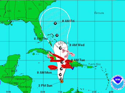
The reason I’ve withheld comment on Hurricane Matthew until now is, well, my Mama taught me, “If you can’t say something nice…” I mean look: here’s this newly-forming tropical system way down in the low latitudes moving merrily westward toward Central America and just as it reaches a longitude due south of Ocracoke, it says, “Wait a minute! The old guy’s still up there in the Outer Banks! Let’s go pay him a visit! Turn right!”
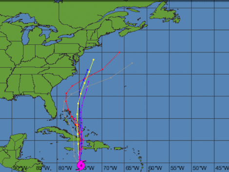
Hey, you know what they say, don’t you? “Just because you’re paranoid doesn’t mean there’s not someone out there trying to get you!” So every time I’d bring up the various weather websites, almost all of the computer models were predicting a 90 degree turn bringing Matthew right to my doorstep just like the FedEx truck.
This morning when I brought up the sites well before dawn, the model consensus, for the first time, actually showed Matthew’s projected path curving safely out to sea, missing us by at least a hundred miles! But just a few hours later the models were back where they had been, putting us square on the bull’s eye.
While I’m enough of a Luddite to eschew cable TV, I do have internet (when it works around here) and I tap into it on my 12-year-old MacBook which I rescued from the trash can when Sundae bought a new one a while back. There’s probably an infinite number of weather sites available online but I’ve narrowed my focus down to four. Years ago, when I confined my reading to the official National Weather Service site, I was frequently frustrated by the way it handled approaching hurricanes. It seemed as if there were two separate divisions of the service that functioned independently of each other with no interoffice communication. One was the regular part that issued forecasts based on all existing and developing conditions except tropical systems. The other was the tropical division that described in detail any tropical waves/depressions/storms or hurricanes. There never seemed to be any mention in the long-range forecast of storm conditions. Then, just as a hurricane would be eminent, there’d be a hurricane warning and all bets were off.
You’d bring up the site and gasp when the regional map was entirely red or purple. They seem to have gotten a little better about that in more recent years but I still like to bring up my favorite four for comparison. They are, in addition to the aforementioned NWS site, Weather.com, Wunderground.com/tropical and Windfinder.com.

Jeff Masters on Wundergound keeps his informative blog up to date, usually giving several new reports each day as conditions warrant. While he sometimes tends to obsess over weather history (who cares if the last category 4 hurricane to hit South America was in 1889?) he’s good at putting meteorological jargon into more or less plain English that most of us can understand.
The 10-day forecast on Weather.com gives you a fairly good idea of how gradual or abrupt the changes ahead may be. But as Matthew developed, after consulting the computer models on Wunderground, I would go to Windfinder for their hourly prediction of wind strengths right here on Ocracoke. For the past few days, as we were staring right down the barrel of Matthew, Windfinder was showing it arriving here on the morning of Saturday, October 8th (of course this has absolutely nothing to do with the fact that October 8th is my birthday!) For several days it was predicting hurricane force winds then with this morning’s more favorable outlook it went briefly down to just gale force only to spring back up with the changing track projections and moving the arrival time from Saturday morning to Friday evening.
Oh well… nothing we can do but wait a few hours and see what the prognosticators have to say next. Right now (early Sunday afternoon) the weather here is about as fine as it gets. Time for a stroll on the beach!


