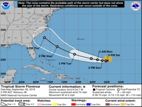
Tropical Storm Florence is forecast to be a dangerous major hurricane near the southeast U.S. coast by late next week, and the risk of direct impacts continues to increase. However, given the uncertainty in track and intensity forecasts at those time ranges, it's too soon to determine the exact timing, location, and magnitude of those impacts.
With the high forecast uncertainty because of the complex weather pattern and low confidence in the long range forecast track, it is critical for everyone to remain vigilant. Although we may have a few days before serious protective measures need to be implemented, at this juncture direct impacts to NC from an extremely powerful hurricane are likely. Citizens should closely monitor Hurricane Florence and continue making preparations should emergency protective measures become required.
Large swells will begin to affect portions of the U.S. East Coast this weekend, resulting in life-threatening surf and rip currents. Beach-goers should exercise extreme caution when deciding to enter the water starting this weekend. Rip currents usually peak during periods of low tide, so when planning your trip to the beach please try to avoid low tide cycles.
Even though the long range forecast is somewhat uncertain, preparedness may alleviate stress and unwanted outcomes exacerbated by waiting for the forecast to materialize.
Individuals should take this opportunity to evaluate their household preparedness by checking/building their emergency preparedness kit, discussing evacuation plans, validating insurance coverage, cataloging valuables, etc.
With the growing probability that Hyde County will receive direct impacts from Florence, non-resident property owners should consider capitalizing on the rest of this weekend through Monday and use it as an opportunity to secure their properties ahead of the storm.
This is a great time to fill up your vehicle with gas and make sure you have adequate back up fuel for vehicles and generators. If you have a generator that is new or has not been run recently, you should fill it up with gas and make sure everything is working properly.
The Hyde County Emergency Services Department will continue to monitor the forecast and issue advisories as appropriate. Also, the Ocracoke Deputy Control Group began meeting this evening to receive daily weather briefings and discuss emergency protective measures. Citizens should monitor their local weather outlets, the National Weather Service Weather Forecast Offices, and the National Hurricane Center for the most timely information.
To see Hyde County's Hurricane and Flood Procedures and Preparation Information,
visit our website at http://hydecountync.gov/hurricane_and_flood_info/index.php