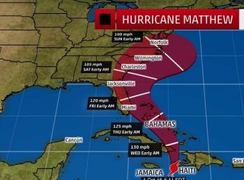
Matthew is forecast to make landfall between South Carolina and North Carolina sometime between Friday, October 7 and Sunday, October 9, 2016. Matthew has the potential to bring dangerous and potentially life threatening storm surge and high surf; damaging strong winds that could produce prolonged power outages; heavy rainfall and flash flooding; tornadoes; extremely dangerous conditions for boaters; and rip currents.
The Ocracoke Control Group is convening regularly and will be meeting today at 5 p.m. Hyde County Government officials will be considering the issuance of emergency protective orders and they could become effective as early as tomorrow.
Make plans now for how you will deal with the potential threats and impacts. Have a disaster preparedness kit ready, and plans for what you would do if asked to evacuate. Closely monitor the forecast for Matthew in the coming days, and be prepared to take action to protect yourself and your property.
Hyde County has already experienced significant rainfall events over the past month and above normal tides over the past several days, so therefore, everyone needs to be aware that flood waters may contain sewage and other harmful contaminants. Please keep children and pets out of flood waters, as these waters can hide pre-existing safety concerns and have undesired health implications.
Please maintain awareness and monitor for further updates from Hyde County Public Information.