I'm thinking about Jamaica, Haiti, Cuba, and the Bahamas right now as they prepare for the worst. The situation looks very scary for them.
Capt. Rob has gone to bed, so we'll have to wait until morning to get his word on Hurricane Matthew, but I'm sure all eyes are glued to the weather channels and seeing that Matthew has achieved Category 5 status. What?
Ocracoke is, as is true all too often, in the "cone of uncertainty." I hate the cone of uncertainty. First I refuse to listen to Rob tell me anything about a tropical wave/depression/storm until I absolutely have to face it. Then I bug Rob every hour or so, "Is it heading here or not? If you don't know yet, WHEN will you know?!?"
I know the Current isn't anybody's primary source of Hurricane forecasting (that would be silly), but we will keep you up to date about how Ocracokers decides to handle this storm. Should we stay or should we go? As the Magic 8 Ball would say, "Ask again later."

Meanwhile, the Hyde County Emergency Management office posted this helpful information:
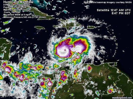
HURRICANE HUNTERS FIND EXTREMELY DANGEROUS MATTHEW WITH 150 MPH WINDS
Since attaining hurricane strength yesterday, Matthew has rapidly intensified over the past 30 hours, a 75 mph increase in sustained winds, despite the unfavorable wind shear and is now a dangerous Category 4 storm with 150 mph sustained winds. Matthew is located south of Haiti and the Dominican Republic, passing closer to South America than any known major hurricane.
Short-term Forecast
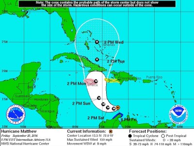
Environmental conditions are expected to become more favorable for development, as available moisture increases and the wind shear relaxes. The major hurricane is moving to the west-southwest at 9 mph and the westward motion has prevented the shear from penetrating the core and introducing dry air. A slow down in forward motion is projected ahead of a turn to the northwest tomorrow and then movement to the north on Sunday into Monday. The current forecast track brings Matthew close to or over Jamaica on Monday afternoon and then the storm will make landfall along the southeast coast of Cuba on Monday night or early Tuesday morning. The mountainous terrains of Jamaica and Cuba should weaken the storm and it is predicted that storm will emerge south of the Bahamas as a strong Category 2 hurricane (105 mph sustained winds) on Tuesday afternoon.

Long-term Forecast
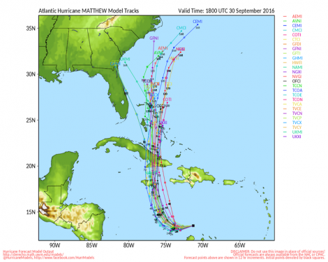
After crossing Cuba, Matthew will continue its trek to the north as a strong Category 2 hurricane. The hurricane will enter the Central Bahamas on Tuesday night into Wednesday morning. Long-range model projections become more divergent as Matthew passes through the Bahamas, but more model strands are indicating that the storm could remain off the North Carolina coast. Due to the wide ranging probabilities, it would be unwise to venture a guess this far out and everyone needs to monitor the forecast very closely. At this juncture, forecasters at the NWS Newport/Morehead City can comfortably predict that Eastern North Carolina will receive large swells producing dangerous rip currents at the very least.
Local Emergency Protective Measures
The Hyde County Emergency Services Department will continue to monitor the forecast and issue advisories as appropriate. Given the current forecast timing, serious discussions regarding emergency preparations and protective measures may begin as early as Sunday or Monday. Matthew is a very dangerous storm and given current conditions, it could pose a significant threat to Eastern North Carolina.
